

Beyond the Bird's-Eye View: Unlocking Detail with the Drone Oblique Route Function
Good afternoon! Let's explore the innovative "Smart Oblique Route Function" in drones. Here's an article for you, along with the requested summaries.
Article: Beyond the Bird's Eye: Unlocking Detail with Drone Smart Oblique Route Functions
In the realm of aerial data collection, simply seeing a flat, top-down view is often not enough. For comprehensive 3D modeling, detailed inspections of vertical structures, or rich contextual mapping, a different perspective is needed. This is where the advanced "Smart Oblique Route Function" in modern drones comes into play, revolutionizing how we capture detailed aerial information.
Traditionally, drone mapping primarily involved capturing nadir (straight-down) imagery. While excellent for 2D orthomosaics and basic terrain models, these images lack the crucial side-angle information needed to accurately reconstruct buildings, bridges, cliffs, or other vertical elements. Manually flying a drone to capture oblique (angled) shots from various directions is time-consuming, prone to inconsistencies, and requires significant pilot skill to ensure sufficient image overlap for processing.
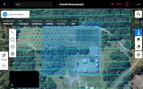
The Smart Oblique Route Function addresses these challenges by automating the complex process of capturing multi-angle imagery. Instead of just flying in a grid pattern directly over the area, the drone calculates and executes a sophisticated flight path that includes multiple passes at different angles relative to the ground. This often involves flying concentric circles or parallel lines around a point of interest, with the camera automatically tilting and capturing images from 45-degree or similar angles, in addition to standard nadir shots.
The "smart" aspect lies in the drone's ability to:
Optimize Flight Paths: The system intelligently plans the most efficient routes to ensure maximum coverage and optimal image overlap from all necessary perspectives, minimizing flight time and battery consumption.
Automate Camera Control: The drone automatically adjusts the camera's gimbal pitch and yaw as it flies, ensuring every image is captured with the precise angle required for later 3D reconstruction.
Ensure Data Quality: By systematically capturing images from multiple perspectives, the function guarantees that photogrammetry software has all the necessary visual data to create highly accurate and detailed 3D models or enhanced 2D maps with rich context.
Key Benefits of Smart Oblique Route Functions:
Superior 3D Models: Produces highly detailed and accurate 3D models of urban environments, individual buildings, industrial sites, and complex terrain, including facades and overhangs.
Enhanced Detail for Inspection: Critical for inspecting vertical surfaces of bridges, towers, dams, and historic structures where a top-down view is insufficient.
Increased Efficiency: Automating complex flight patterns saves significant time and effort compared to manual oblique capture.
Reduced Pilot Workload: Frees up the pilot to monitor flight safety and data quality rather than manually controlling complex camera movements.
Comprehensive Data Capture: Ensures no crucial angles or details are missed, leading to more complete and reliable datasets.
Applications Across Industries:
Urban Planning & Smart Cities: Creating highly accurate 3D city models for development planning, sunlight analysis, and virtual tourism.
Architecture, Engineering & Construction (AEC): Detailed site mapping, progress monitoring, and as-built documentation for complex structures.
Heritage Preservation: Digitally documenting historical buildings and monuments in full 3D for conservation, restoration, and public access.
Infrastructure Inspection: Comprehensive visual inspection of bridges, wind turbines, power lines, and communication towers.
Insurance & Damage Assessment: Rapidly capturing detailed 3D evidence of damage to buildings after natural disasters or incidents.
The Smart Oblique Route Function is a testament to the continuous innovation in drone technology. By allowing for automated, comprehensive, and precise capture of multi-angle imagery, it opens up new possibilities for detailed spatial analysis, 3D modeling, and inspection, transforming how industries gather and utilize aerial data.