

Our Services
We provide comprehensive 3D mapping and visual documentation solutions through a combination of aerial and ground-based technologies.
From high-precision surveys and photogrammetry to detailed indoor digital twins and immersive 360° walkthroughs, we create accurate, interactive models of both large-scale sites and interior spaces.
Our services empower real estate, construction, and asset management teams with powerful visual tools for planning, progress tracking, and informed decision-making.
Drone SURVEY
(Housing & Commercial Development)
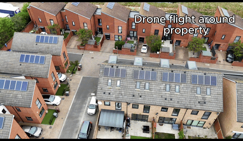
Our drone flyover and 360° view service provides high-quality aerial imagery, including smooth flyover footage and interactive 360° views, to deliver comprehensive visual insights of your property or site. This service is ideal for a range of applications, including project monitoring, marketing, and detailed inspections.
Property owners, developers, and businesses can leverage our dynamic visuals to effectively showcase their spaces, track construction progress, and gain valuable aerial perspectives for informed decision-making.
Benefits:
✓ Safer Inspections
✓ Cost-Effective Solution
✓ Detailed Visual Data
✓ Precise Measurement Capabilities
✓ 3D Model
✓ High-resolution pictures & videos
360 Virtual Walkthrough
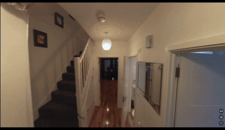
Our internal 360° view service creates immersive, high-quality virtual walkthroughs, offering users complete control to explore spaces remotely.
This interactive solution provides a detailed visual record, ideal for showcasing properties, documenting project stages, or enhancing inspections.
Perfect for real estate, construction, and property management professionals seeking to provide engaging and informative experiences
Benefits:
✓ Immersive Experience
✓ Remote Exploration
✓ 360° Viewing
✓ Interactive Navigation
✓ Easy Sharing
✓ Versatile Application
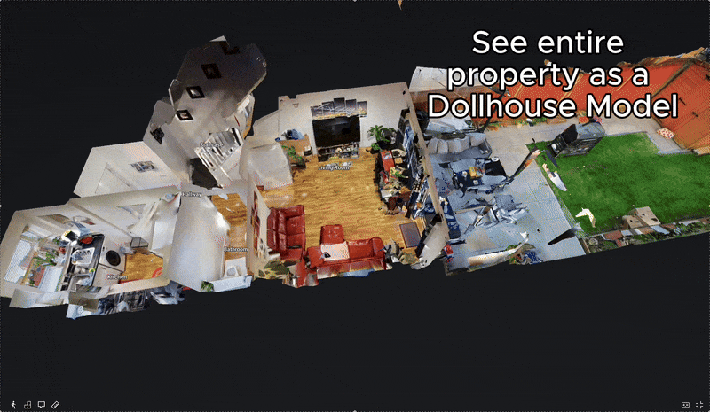
DOLLHOUSE Walkthrough
(Housing & Commercial Development)
Discover a powerful new way to visualize spaces with our Dollhouse Walkthrough.
Our virtual walkthrough videos go beyond static imagery, offering interactive navigation where you can click to proceed, pause to observe, and freely look around.
Enhance your understanding with integrated features that allow for on-screen measurements and the ability to view a detailed floor plan.
Benefits:
✓ Interactive 360° Experience
✓ User-Controlled Navigation
✓ Design & Floor Plan integration
✓ Integrated Measurement Tools
✓ Remote Access and Flexibility
✓ Improved Decision-Making
✓ Resolve Commercial disputes
Drone Inspections
(Roof & Facade)
Our drone inspection service provides safe, efficient, and cost-effective high-resolution aerial surveys of roofs and facades.
Utilizing advanced imaging technology, we deliver detailed visual assessments without the risks and costs associated with scaffolding or manual inspections. Ideal for property owners, surveyors, and maintenance teams seeking precise and minimally disruptive condition monitoring.
Benefits:
✓ Safer Inspections
✓ Cost-Effective Solution
✓ Detailed Visual Data
✓ Precise Measurement Capabilities
✓ 3D Model
✓ High-resolution pictures & videos
3D As Built

Our 3D As-Built service provides highly accurate, detailed 3D models of completed construction projects. Utilizing advanced drone technology and processing, we capture and integrate data to create precise representations of both above-ground structures and below-ground utilities.
This service is essential for verifying construction accuracy, managing assets, and preventing costly clashes during future modifications or expansions.
Benefits:
✓ Area Mapping
✓ Detailed Visual Data
✓ Precise Measurement Capabilities
✓ 3D Model (High-precision)
✓ Millimetre-level resolution
✓ Design integration
Volumetric Analysis

Gain valuable insights into your site with our volumetric analysis service. Using drone survey data, we generate detailed reports and 3D visualizations of material quantities, enabling you to effectively manage inventory, track site progress, and optimize resource allocation.
Our service delivers the data you need to improve efficiency and reduce costs on large-scale projects.
Benefits:
✓ User-Controlled Navigation
✓ Remote Access & Collaboration
✓ Measurement Capabilities
✓ Design integration
2d map
2D drone topographic maps, also known as orthomosaics, are valuable for a variety of applications due to their ability to provide a highly detailed, accurate, and bird's-eye view of an area.
They are particularly useful for construction site planning, land management, and progress monitoring, as they offer precise measurements and visual insights into terrain and features.

Benefits:
✓ Detailed Visual Data
✓ Accurate Volume Calculations
✓ Design integration
✓ Easy control & Dispute resolution
3D Model

We create high-accuracy 3D maps that capture large areas quickly and safely. This process reduces field time, enhances safety, and delivers detailed models for use in construction, infrastructure, and asset management.
With rapid processing and easy integration into CAD and GIS platforms, it’s a reliable way to document sites, monitor progress, and support smarter decision-making.
Benefits:
✓ Area Mapping
✓ Remote Access & Easy Navigation
✓ Measurement Capabilities
✓ 3D Model
✓ Design integration
Follow up package

Empower your project management with our scheduled drone progress updates and 360° virtual walkthrough service. This service delivers high-resolution aerial imagery at pre-arranged intervals, providing the visual information needed for accurate progress assessment, improved project control, and confident decision-making.
Perfect for construction sites, renovations, and large-scale developments where consistent visual documentation is critical.
Contact us
Interested in working together? Fill out some info and we will be in touch shortly. We can’t wait to hear from you!