

Commercial (Facilities, WAhourses, Office Buildings)
Total Site Clarity—Without Disruption
Managing commercial property requires more than just blueprints—it demands real-time, visual accuracy. Our digital walkthroughs and aerial data give you a full view of your premises, supporting space planning, asset management, insurance documentation, and safety audits.
All outputs integrate seamlessly with AutoCAD, BIM, and digital twin environments to support every stage of your workflow.
If you could see your building as clearly as your spreadsheets—what would change?
DOLLHOUSE Walkthrough

Description:
Large indoor spaces are captured quickly with high precision, producing accurate 3D scans and floorplans for documentation, planning, or verification.
Anyone can explore the space virtually, reducing the need for site visits and making collaboration easier across teams and locations.
Clear visuals and precise measurements support smarter layout decisions, efficient renovations, and more professional client or investor presentations.
Benefits:
✓ Accurate indoor 3D scans
✓ Fast large-space capture
✓ Detailed floorplan output
✓ Easy remote walkthroughs
✓ Improves space planning
✓ Professional client visuals
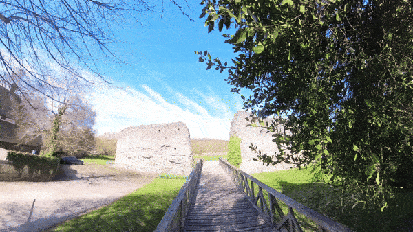
360 Virtual Walkthrough
Description:
A virtual walkthrough using 360° imagery lets users look around and “walk through” a from any browser. It’s a quick, cost-effective way to capture interiors for documentation, stakeholder updates, or compliance checks.
These walkthroughs are useful for weekly progress checks, vendor briefings, or equipment tracking inside & outside buildings. It provides a visual history that can be reviewed anytime, reducing site visits and simplifying project communication.
Benefits:
✓ Fast interior capture
✓ Visual status audit
✓ Minimal disruption
✓ Easy sharing
✓ Remote training
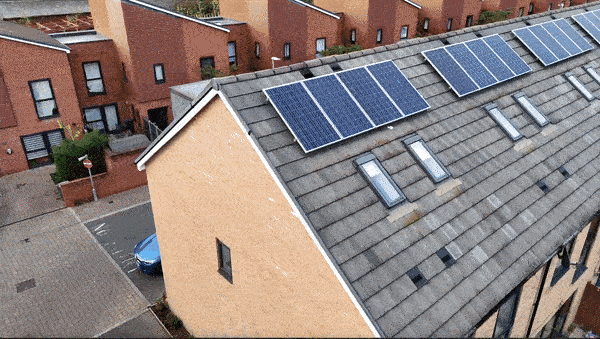
Drone Inspections
Description:
Drone inspections are perfect for surveying rooftops, facades, and tall structures without needing lifts or physical access. High-resolution imagery allows for clear identification of defects, water damage, or other maintenance issues from a safe distance.
By reducing the time and risk involved in manual inspections, your maintenance cycles become more efficient and proactive. It’s an excellent tool for facility managers, insurers, or construction supervisors who need reliable visuals without interrupting operations.
Benefits:
✓ Safer Inspections
✓ Cost-Effective Solution
✓ Detailed Visual Data
✓ No Scaffolding Needed
✓ High-resolution pictures & videos
3D As-Built

Description:
Smart 3D As-Built capture produces centimeter-accurate models, ideal for checking alignment, elevations, and dimensions. It confirms if built work matches design, unlike standard 3D models which lack this precision.
It captures dense, high-resolution data over large or complex sites, with minimal ground work. Hard-to-reach or live areas are covered safely and quickly, improving both speed and safety.
The model becomes a reliable digital record for tracking progress, quality checks, and client reporting. It helps detect issues early, supports smooth handover, and builds trust with clear, accurate documentation.
Benefits:
✓ Centimeter-accurate site data
✓ Verify build to design
✓ Fine-detail structure capture
✓ Precision measurements for QA
✓ Detect deviations early
✓ Trusted client documentation
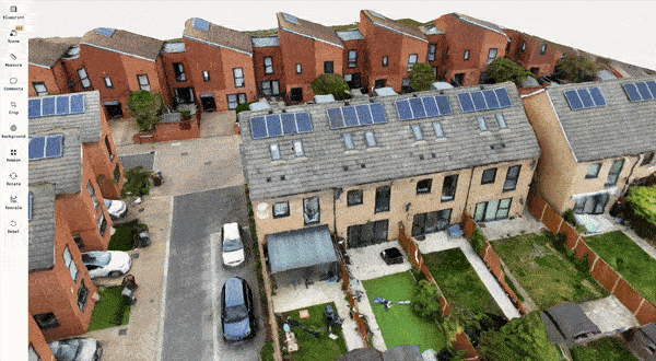
3D Model
Description:
A 3D model provides a detailed digital replica of a commercial building or warehouse. It helps facility teams and stakeholders visualise layouts, structures, and ongoing work without needing to visit the site, reducing miscommunication and improving planning.
Drones eliminate the need for manual inspections in hard-to-access or hazardous areas. Data is captured quickly, cutting time on-site and improving safety while keeping operations efficient.
The model enables accurate measurements, space planning, and progress tracking. It supports better decisions by giving teams a clear, current view of the facility, reducing errors, delays, and costs.
Benefits:
✓ Area Mapping
✓ Remote Access & Easy Navigation
✓ Measurement Capabilities
✓ 3D Model
✓ Design integration
✓ Expansion planning
Aerial Photo & Video
Description:
Aerial photos and videos offer a compelling way to showcase your facility or project. From highlighting scale and layout to capturing dynamic movement, these visuals are perfect for presentations, reports, or even digital marketing.
They also serve as a record of changes over time. Whether it's construction progress, completed upgrades, or site activity, aerial media adds clarity and polish that ground-based photography can't match. It's a powerful visual asset for any professional setting.
Benefits:
✓ Safer Inspections
✓ Cost-Effective Solution
✓ Site Layout Clarity
✓ Public Engagement
✓ Training Support
Follow up package

Empower your project management with our scheduled drone progress updates and 360° virtual walkthrough service. This service delivers high-resolution aerial imagery at pre-arranged intervals, providing the visual information needed for accurate progress assessment, improved project control, and confident decision-making.
Perfect for construction sites, renovations, and large-scale developments where consistent visual documentation is critical.
Contact us
Interested in working together? Fill out some info and we will be in touch shortly. We can’t wait to hear from you!