

Monuments & Historic Sites (Heritage, Trusts, Government)
Preserve the Past—Precisely and Digitally
Heritage sites deserve care, accuracy, and long-term insight. We provide detailed, high-resolution visual surveys that support conservation planning, architectural research, and public engagement—capturing every stone and surface, safely and non-invasively.
Our outputs integrate with heritage CAD drawings, restoration plans, and BIM archives—helping you preserve what matters for generations to come.
How well can you protect history if you can’t fully see it?
3D As-Built
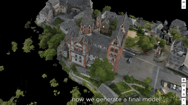
Description:
High-accuracy 3D as-built capture creates a faithful digital replica of the monument, accurate to the centimeter. It records fine architectural details such as stonework, arches, and elevation changes with exceptional clarity.
This level of detail is critical for preservation teams working on restoration or structural stabilization. It allows planners to detect misalignments, weathering, or shifting that may not be visible to the naked eye.
The model acts as a digital reference for future generations—useful for funding bodies, planning approvals, or academic studies. It ensures that the castle’s current form is permanently recorded in precise, measurable form.
Benefits:
✓ Precision Mapping
✓ Restoration Planning
✓ Historic Accuracy
✓ Structural Validation
✓ Condition Monitoring
✓ Archival Reference
Dollhouse WAlthrough


Description:
The LIDAR-powered dollhouse view gives a highly accurate, interactive 3D model of the entire monument, including interior levels, staircases, and structural flow. Users can rotate the full model or step into individual rooms.
This format helps conservationists visualize and plan complex interventions while giving stakeholders a clear understanding of the monument’s internal structure. It supports funding requests, reporting, and project planning with measurable accuracy.
For public outreach, it provides an engaging, tech-forward way to explore heritage. Whether embedded online or displayed in a museum kiosk, it helps bring the past into present-day access.
Benefits:
✓ Interactive Model
✓ Layout Exploration
✓ Digital Preservation
✓ Spatial Analysis
✓ Space Documentation
✓ Public Education
Follow Up Package

Empower your project management with our scheduled drone progress updates and 360° virtual walkthrough service. This service delivers high-resolution aerial imagery at pre-arranged intervals, providing the visual information needed for accurate progress assessment, improved project control, and confident decision-making.
Perfect for construction sites, renovations, and large-scale developments where consistent visual documentation is critical.
Contact us
Interested in working together? Fill out some info and we will be in touch shortly. We can’t wait to hear from you!